San Juan County, 1955-1958
File — Tube: 206
Identifier: X
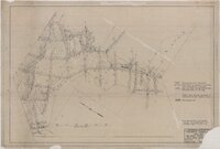
Company sample map : Jen, Inc., Big Indian Mining District, San Juan County, Utah
District geology : Jen, Inc., Big Indian Mining District, San Juan County, Utah
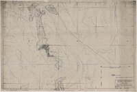
Grade contour map, hundredths of percent U3O8 : Jen, Inc. : Big Indian Mining District, San Juan County, Utah
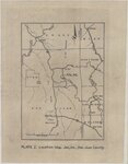
Plate I: Location map, Jen Inc., San Juan County
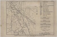
Plate II: Geologic map of Lisbon Valley and Big Indian Wash, San Juan County

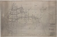
Channel sample map, blocks 13 & 14 : Jen, Inc., Big Indian Mining District, San Juan County, Utah
Scope and Contents
- Blue Lizard mine, Lucky Strike Uranium Corporation, San Juan County, Utah (1955)
- Techmanix Corporation, district geology, Jen, Inc., Big Indian Mining District, San Juan County, Utah (1958)
- Property of Empire Petroleum Company, San Juan County, Utah
- Cut sample map, E. L. Cord mine - ore level, San Juan County, Utah (1957)
Dates
- Creation: 1955-1958
Creator
- From the Collection: Snyder, Edward H. (Edward Harrison), 1889-1967 (Person)
Conditions Governing Access
Twenty-four hour advanced notice encouraged. Materials must be used on-site. Access to parts of this Collection may be restricted under provisions of state or federal law.
Extent
From the Collection: 148 Linear Feet
Language of Materials
From the Collection: English
- Company sample map : Jen, Inc., Big Indian Mining District, San Juan County, Utah
- District geology : Jen, Inc., Big Indian Mining District, San Juan County, Utah
- Grade contour map, hundredths of percent U3O8 : Jen, Inc. : Big Indian Mining District, San Juan County, Utah
- Plate I: Location map, Jen Inc., San Juan County
- Plate II: Geologic map of Lisbon Valley and Big Indian Wash, San Juan County
- Channel sample map, blocks 13 & 14 : Jen, Inc., Big Indian Mining District, San Juan County, Utah
Repository Details
Part of the J. Willard Marriott Library Special Collections Repository
Contact:
295 South 1500 East
Salt Lake City Utah 84112 United States
801-581-8863
special@library.utah.edu
295 South 1500 East
Salt Lake City Utah 84112 United States
801-581-8863
special@library.utah.edu